Professor Mark Bateman
School of Geography and Planning
Professor in Palaeoenvironmental Reconstruction


+44 114 222 7929
Full contact details
School of Geography and Planning
Geography and Planning Building
Winter Street
Sheffield
S3 7ND
- Profile
-
Mark Bateman received a First Class BSc in Geography from the University of London in 1991 and a DPhil from Sussex University in 1995 for his research on dating UK coversands. In 1995 he joined the Sheffield Geography department as a post-doctoral research assistant to set up and run the luminescence laboratory for the Sheffield Centre for International Drylands Research.
In 1998, Mark Bateman was appointed Lecturer in Physical Geography, promoted to Senior Lecturer (2004), Reader in Palaeoenvironmental Reconstruction (2006), and became a Professor in 2011. In 2018 he was awarded the Sorby medal by the Yorkshire Geological Society for his contribution to Yorkshire Geology.
- Qualifications
-
- BSc in Geography
- DPhil in Geography
- Senior Fellow of the Higher Education Academy
- Research interests
-
Society faces a Climate Crisis with a number of challenges including rising sea-levels, melting ice, desertification and increased storminess. My research aims to make a contribution towards understanding these changes by understanding the causes and magnitude of past environmental changes. It focuses on Sandscapes as an archive for understanding past depositional processes and environmental changes which have shaped the landscape we live in. Three themes are centred around this:
- Past glacial and periglacial landscapes
- Past aeolian activity in deserts and on coasts
- Advances in Luminescence dating of sediments
- The wider past environments in which our human predecessors were living
- Publications
-
Books
Journal articles
- Geochronology of the Whittlesey sedimentary succession, eastern England: the ‘Pompeii’ of the British late Middle Pleistocene to Holocene record. Journal of Quaternary Science. View this article in WRRO


- Developing a new approach to the luminescence dating of sediments from glacial contexts. Quaternary Geochronology, 87, 101659-101659.


- Humans in Africa’s wet tropical forests 150 thousand years ago. Nature, 640, 402-407. View this article in WRRO


- Constraining the age of the Middle Stone Age locality of Bargny (Senegal) through a combined OSL-ESR dating approach. Quaternary Environments and Humans, 2(6), 100044-100044.


- How old are the Mojave topographic dunes? The implications of new luminescence dating analyses from the Cady Mountains, Mojave Desert, southwest USA. Geomorphology, 463. View this article in WRRO


- Extending the ESR and OSL dating comparison on coastal dune deposits from the Wilderness-Knysna area (South Africa). Quaternary Geochronology, 83. View this article in WRRO


- Probing sediment burial age, provenance and geomorphic processes in dryland dunes and lake shorelines using portable luminescence data. Quaternary Geochronology, 82. View this article in WRRO


- Disentangling late quaternary fluvial and climatic drivers of palaeohydrological change in the Najaf Sea basin, Western Iraq. Earth Surface Processes and Landforms, 49(4), 1451-1467. View this article in WRRO


- Pleistocene fossil snake traces on South Africa’s Cape south coast. Ichnos: an International Journal of Plant and Animal Traces, 30(2), 98-114. View this article in WRRO


- The magnitude and source of meltwater forcing of the 8.2 ka climate event constrained by relative sea-level data from eastern Scotland. Quaternary Science Advances, 12. View this article in WRRO


- A revision of the British chronostratigraphy within the last glacial-interglacial cycle based on new evidence from Arclid, Cheshire UK. Quaternary Science Reviews, 299. View this article in WRRO


- Eurasian Ice Sheet derived meltwater pulses and their role in driving atmospheric dust activity: late Quaternary loess sources in SE England. Quaternary Science Reviews, 296.


- Growth and retreat of the last British–Irish Ice Sheet, 31 000 to 15 000 years ago : the BRITICE‐CHRONO reconstruction. Boreas, 51(4), 699-758. View this article in WRRO


- Timing and dynamics of Late Wolstonian Substage ‘Moreton Stadial’ (MIS 6) glaciation in the English West Midlands, UK. Royal Society Open Science, 9(6).


- Getting the right age? Testing luminescence dating of both quartz and feldspars against independent age controls. Quaternary Geochronology, 72. View this article in WRRO


- Late quaternary alluvial history of the Brazos River in central Texas. Quaternary International, 631, 34-46. View this article in WRRO


- ESR dating of optically bleached quartz grains from Plio-Pleistocene to Holocene coastal dune deposits (Wilderness-Knysna area, South Africa): a comparison with luminescence. Quaternary Geochronology, 70. View this article in WRRO


- New geomorphic evidence for a multi‐stage proglacial lake associated with the former British–Irish Ice Sheet in the Vale of Pickering, Yorkshire, UK. Journal of Quaternary Science, 37(8), 1407-1421. View this article in WRRO


- A pilot study into the geochronological and geomorphic context for the archaeology of Barrow Island, Western Australia. Quaternary International, 638-639, 5-22. View this article in WRRO


- Luminescence dating of a late Middle Pleistocene glacial advance in eastern England. Netherlands Journal of Geosciences, 100.


- The evolution of the terrestrial‐terminating Irish Sea glacier during the last glaciation. Journal of Quaternary Science, 36(5), 752-779.


- Pattern, style and timing of British–Irish Ice Sheet retreat : Shetland and northern North Sea sector. Journal of Quaternary Science, 36(5), 681-722.


- Detailing the impact of the Storegga Tsunami at Montrose, Scotland. Boreas, 50(4), 1059-1078.


- Exploring controls of the early and stepped deglaciation on the western margin of the British Irish Ice Sheet. Journal of Quaternary Science, 36(5), 833-870. View this article in WRRO


- Possible new evidence for Mid-Pleistocene glaciation in the Vale of Pickering, North Yorkshire, UK. Proceedings of the Yorkshire Geological Society, 63(4). View this article in WRRO


- Maximum extent and readvance dynamics of the Irish Sea Ice Stream and Irish Sea Glacier since the Last Glacial Maximum. Journal of Quaternary Science, 36(5), 780-804.


- Pattern, style and timing of British–Irish Ice Sheet advance and retreat over the last 45 000 years: evidence from NW Scotland and the adjacent continental shelf. Journal of Quaternary Science, 36(5), 871-933.


- Retreat dynamics of the eastern sector of the British–Irish Ice Sheet during the last glaciation. Journal of Quaternary Science, 36(5), 723-751.


- A 14000 year multi-proxy alluvial record of ecotone changes in a Fynbos-Succulent Karoo transition in South Africa. Palaeogeography, Palaeoclimatology, Palaeoecology, 569. View this article in WRRO


- Continuity of the Middle Stone Age into the Holocene. Scientific Reports, 11(1).


- Farndon fields, Newark, Nottinghamshire: Windermere interstadial deposits with potential for late upper palaeolithic human activity. Mercian Geologist, 20(1), 5-14. View this article in WRRO


- The Middle Stone Age occupations of Tiémassas, coastal West Africa, between 62 and 25 thousand years ago. Journal of Archaeological Science: Reports, 34(Part B). View this article in WRRO


- Understanding historical coastal spit evolution : a case study from Spurn, East Yorkshire, UK. Earth Surface Processes and Landforms, 45(14), 3670-3686.


- Mapping and chronology of coversands and dunes from the Aquitaine basin, southwest France. Aeolian Research, 47. View this article in WRRO


- Seasonal control on coastal dune morphostratigraphy under a monsoon climate, Mui Ne dunefield, SE Vietnam. Geomorphology, 370. View this article in WRRO


- Oriented-lake development in the context of late Quaternary landscape evolution, McKinley Bay Coastal Plain, western Arctic Canada. Quaternary Science Reviews, 242. View this article in WRRO


- The Holocene humid period in the Nefud Desert: Hunters and herders in the Jebel Oraf palaeolake basin, Saudi Arabia. Journal of Arid Environments, 178.


- Long-term sediment decline causes ongoing shrinkage of the Mekong megadelta, Vietnam. Scientific Reports, 10(1).


- A chronology for North Sea Lobe advance and recession on the Lincolnshire and Norfolk coasts during MIS 2 and 6. Proceedings of the Geologists Association, 130(5), 523-540. View this article in WRRO


- Testing the mid-Holocene relative sea-level highstand hypothesis in North Wales, UK. The Holocene, 29(9), 1491-1502.


- Minjiwarra : archaeological evidence of human occupation of Australia’s northern Kimberley by 50,000 BP. Australian Archaeology, 85(2), 115-125.


- Mid-Devensian climate and landscape in England : new data from Finningley, South Yorkshire. Royal Society Open Science, 6(7).


- The mixed‐bed glacial landform imprint of the North Sea Lobe in the western North Sea. Earth Surface Processes and Landforms, 44(6), 1233-1258. View this article in WRRO


- A low-cost bench-top research device for turbidity measurement by radially distributed illumination intensity sensing at multiple wavelengths. HardwareX, 5. View this article in WRRO


- Historical evolution and controls on mega-blowouts in northeastern Qinghai-Tibetan Plateau, China. Geomorphology, 329, 17-31. View this article in WRRO


- Mega-blowouts in Qinghai–Tibet Plateau: morphology, distribution and initiation.. Earth Surface Processes and Landforms, 44(2), 449-458. View this article in WRRO


- First chronostratigraphic framework of fluvial terrace systems in the eastern Cantabrian margin (Bay of Biscay, Spain). Quaternary Geochronology, 49, 108-114.


- Using a portable luminescence reader for rapid age assessment of aeolian sediments for reconstructing dunefield landscape evolution in southern Africa. Quaternary Geochronology, 49, 57-64. View this article in WRRO


- OSL dating of sediments samples from Karun river traces in Khuzestan, SW Iran. Journal of the Earth and Space Physics, 45(2), 299-312.


- First evidence for onshore marine isotope stage 3 aeolianite formation on the southern Cape coastline of South Africa. Marine Geology, 407, 1-15. View this article in WRRO


- Response to the discussion by Van Vliet-Lanoë et al. of the paper ‘Features caused by ground ice growth and decay in Late Pleistocene fluvial deposits, Paris Basin, France’ (Bertran et al., 2018, Geomorphology 310, 84–101). Geomorphology, 327, 629-633. View this article in WRRO


- Late Holocene landscape instability in the Breckland (England) drift sands. Geomorphology, 323, 123-134. View this article in WRRO


- A Pleistocene Thrust Fault in Anorthosite of the Rustenburg Layered Suite near Mooinooi, North West Province, South Africa: Neotectonic Implications. South African Journal of Geology, 121(4), 421-430.


- Ice marginal dynamics of the last British-Irish Ice Sheet in the southern North Sea: Ice limits, timing and the influence of the Dogger Bank. Quaternary Science Reviews, 198, 181-207. View this article in WRRO


- Sedimentation during Marine Isotope Stage 3 at the eastern margins of the Glacial Lake Humber basin, England. Journal of Quaternary Science, 33(8), 871-891. View this article in WRRO


- Sedimentary records of coastal storm surges: Evidence of the 1953 North Sea event. Marine Geology, 403, 262-270. View this article in WRRO


- Features caused by ground ice growth and decay in Late Pleistocene fluvial deposits, Paris Basin, France. Geomorphology, 310, 84-101. View this article in WRRO


- Can glacial shearing of sediment reset the signal used for luminescence dating?. Geomorphology, 306, 90-101. View this article in WRRO


- Late Quaternary coastal evolution and aeolian sedimentation in the tectonically-active southern Atacama Desert, Chile. Palaeogeography, Palaeoclimatology, Palaeoecology, 490, 546-562. View this article in WRRO


- The chronology of Late Pleistocene thermal contraction cracking derived from sand wedge OSL dating in central and southern France. Global and Planetary Change, 162, 84-100. View this article in WRRO


- BRITICE Glacial Map, version 2: a map and GIS database of glacial landforms of the last British–Irish Ice Sheet. Boreas, 47(1), 11-e8. View this article in WRRO


- Can sand dunes be used to study historic storm events?. Earth Surface Processes and Landforms, 43(4), 779-790. View this article in WRRO


- The timing and consequences of the blockage of the Humber Gap by the last British−Irish Ice Sheet. Boreas, 47(1), 41-61. View this article in WRRO


- Early to mid Wisconsin Fluvial Deposits and Palaeoenvironment of the Kidluit Formation, Tuktoyaktuk Coastlands, Western Arctic Canada. Permafrost and Periglacial Processes, 28(3), 523-533. View this article in WRRO


- Book Review. Proceedings of the Geologists' Association, 128(2), 296-297.


- Glacial Lake Pickering: Stratigraphy and chronology of a proglacial lake dammed by the North Sea Lobe of the British-Irish Ice Sheet. Journal of Quaternary Science, 32(2), 295-310. View this article in WRRO


- Persistence of Middle Stone Age technology to the Pleistocene/Holocene transition supports a complex hominin evolutionary scenario in West Africa. Journal of Archaeological Science: Reports, 11, 639-646. View this article in WRRO


- New age constraints for the limit of the British–Irish Ice Sheet on the Isles of Scilly. Journal of Quaternary Science, 32(1), 48-62. View this article in WRRO


- Devising quality assurance procedures for assessment of legacy geochronological data relating to deglaciation of the last British-Irish Ice Sheet. Earth-Science Reviews, 164, 232-250. View this article in WRRO


- The 'Lindholme Advance' and the extent of the Last Glacial Maximum in the Vale of York. Mercian Geologist, 19(1), 18-25. View this article in WRRO


- Early modern human fossils: A tale of earthquakes and cannibalism. Quaternary International, 404, 212-212.


- Vegetation and climate dynamics during the last glacial period in the fynbos-afrotemperate forest ecotone, southern Cape, South Africa. Quaternary International, 404, 136-149.


- Late Holocene aeolian sedimentation in the Tottori coastal dune field, Japan Sea, affected by the East Asian winter monsoon. Quaternary International, 397, 147-158.


- Reconstruction and Modelling of Past Permafrost and Periglacial Environments. Permafrost and Periglacial Processes, 27(1), 3-5.


- A new multi-stage recession model for Proglacial Lake Humber during the retreat of the last British-Irish Ice Sheet. Boreas, 45(1), 133-151. View this article in WRRO


- Late Quaternary sea-level changes of the Persian Gulf. Quaternary Research, 84(1), 69-81.


- A late Pleistocene–Holocene multi‐proxy record of palaeoenvironmental change from Still Bay, southern Cape Coast, South Africa. Journal of Quaternary Science, 30(8), 870-885.


- Last glacial dynamics of the Vale of York and North Sea lobes of the British and Irish ice sheet. Proceedings of the Geologists' Association, 126(6), 712-730. View this article in WRRO


- Rapid age assessment in the Namib Sand Sea using a portable luminescence reader. Quaternary Geochronology, 30, 134-140.


- Instant luminescence chronologies? High resolution luminescence profiles using a portable luminescence reader. Quaternary Geochronology, 30, 141-146. View this article in WRRO


- The Quaternary coversands of southwest France. Quaternary Science Reviews, 124, 84-105.


- Palaeoenvironmental Interpretation of Yedoma Silt (Ice Complex) Deposition as Cold-Climate Loess, Duvanny Yar, Northeast Siberia. Permafrost and Periglacial Processes, 26(3), 208-288. View this article in WRRO


- Discriminating between subglacial and proglacial lake sediments: an example from the Dänischer Wohld Peninsula, northern Germany. Quaternary Science Reviews, 112, 86-108. View this article in WRRO


- Identifying evidence for past mining and metallurgy from a record of metal contamination preserved in an ombrotrophic mire near Leadhills, SW Scotland, UK. The Holocene, 24(12), 1719-1730.


- Understanding Late Quaternary change at the land ocean interface: a synthesis of the evolution of the Wilderness coastline, South Africa. Quaternary Science Reviews, 99(1), 210-223. View this article in WRRO


- A prospectus for future geomorphological investigation of the Namib Sand Sea. Transactions of the Royal Society of South Africa, 69(3), 151-156.


- The evolution of periglacial patterned ground in East Anglia, UK. Journal of Quaternary Science, 29(4), 301-317.


- Effects of ivermectin residues on dung invertebrate communities in a UK farmland habitat. Insect Conservation and Diversity, 7(1), 64-72.


- The aeolian sand record in the Trent valley. Mercian Geologist, 18(2), 108-118.


- Chronologies and the Quaternary record - Introduction. BOREAS, 42(2), 257-258.


- Aeolian Processes in Periglacial Environments, 8, 416-429.


- The Landes de Gascogne (southwest France): Periglacial desert and cultural frontier during the Palaeolithic. Journal of Archaeological Science, 40(5), 2274-2285.


- Luminescence dating of beach ridges for characterizing multi-decadal to centennial deltaic shoreline changes during Late Holocene, Mekong River delta. Marine Geology, 326-328, 140-153.


- On the formation of sand ramps: A case study from the Mojave Desert. Geomorphology, 161-162, 93-109.


- Investigating the effects of glacial shearing of sediment on luminescence. Quaternary Geochronology, 10, 230-236.


- Juxtaposed beach ridges and foredunes within a ridge plain - Wonga Beach, northeast Australia. Marine Geology, 307-310, 111-116.


- Origin and evolution of interdistributary delta plains; insights from Mekong River delta. GEOLOGY, 40(4), 303-306.


- New evidence for large earthquakes on the Central Iran plateau: Palaeoseismology of the Anar fault. Geophysical Journal International, 189(1), 6-18.


- Evidence for land degradation from aeolian sediment in the west-central free state province, South Africa. Land Degradation and Development, 23(6), 601-610.


- Evidence of Saharan dust in upper Pleistocene reworked palaeosols of North-west Sardinia, Italy: Palaeoenvironmental implications. Sedimentology, 59(3), 917-938.


- Building of shore-oblique transverse dune ridges revealed by ground-penetrating radar and optical dating over the last 500 years on Tottori coast, Japan Sea. Geomorphology.


- Coastal barrier dune construction during sea-level highstands in MIS 3 and 5a on Tottori coast-line, Japan. Palaeogeography, Palaeoclimatology, Palaeoecology.


- Regional and global context of the Late Cenozoic Langebaanweg (LBW) palaeontological site: West Coast of South Africa. Earth-Science Reviews.


- Inland aeolian deposits of south-west France: Facies, stratigraphy and chronology. Journal of Quaternary Science.


- Dating inset terraces and offset fans along the Dehshir Fault (Iran) combining cosmogenic and OSL methods. Geophysical Journal International.


- Re-evaluation of the Last Glacial Maximum typesite at Dimlington, UK. Boreas.


- The evolution of coastal barrier systems: A case study of the Middle-Late Pleistocene Wilderness barriers, South Africa. Quaternary Science Reviews, 30(1-2), 63-81.


- The last interglacial sea-level high stand on the southern Cape coastline of South Africa. QUATERNARY RES, 73(2), 351-363.


- Beach ridge plain evidence of a variable late-Holocene tropical cyclone climate, North Queensland, Australia. Palaeogeography Palaeoclimatology Palaeoecology, 297(3-4), 707-716.


- New evidence for the age and palaeoecology of the Knysna formation, South Africa. South African Journal of Geology, 113(3), 241-256.


- Guest Editorial: Sheffield 2009-From Landscape to Laboratory and Back Again. GEOARCHAEOLOGY, 25(6), 671-674.


- Understanding geomorphic responses to environmental change: a 19 000-year case study from semi-arid central Texas, USA. J QUATERNARY SCI, 25(6), 889-902.


- Sediment provenance of the Wilderness barrier dunes, southern Cape coast, South Africa. Terra Nova, 22(6), 417-423.


- Identification of Younger Dryas outburst flood path from Lake Agassiz to the Arctic Ocean. NATURE, 464(7289), 740-743.


- Geomorphic history of low-perched, transgressive dune complexes along the southeastern shore of Lake Michigan. Aeolian Research, 1(3-4), 111-127.


- The Namib Sand Sea digital database of aeolian dunes and key forcing variables. Aeolian Research, 2(2-3), 93-104.


- New radiometric dating of water management features at the prehistoric Purron Dam Complex, Tehuacan Valley, Puebla, Mexico. J ARCHAEOL SCI, 37(6), 1207-1213.


- First evidence for large earthquakes on the Deshir Fault, Central Iran Plateau. TERRA NOVA, 21(6), 417-426.


- Holocene right-slip rate determined by cosmogenic and OSL dating on the Anar fault, Central Iran. GEOPHYS J INT, 179(2), 700-710.


- Luminescence dating indicates radiocarbon age underestimation in late Pleistocene fluvial deposits from eastern England. J QUATERNARY SCI, 24(8), 916-927.


- West coast dune plumes: Climate driven contrasts in dunefield morphogenesis along the western and southern South African coasts. PALAEOGEOGR PALAEOCL, 271(1-2), 24-38.


- First evidence for episodic flooding events in the arid interior of central Saudi Arabia over the last 60 ka. J QUATERNARY SCI, 24(2), 198-207.


- A Holocene-late Pleistocene aeolian record from lunette dunes of the western Free State panfield, South Africa. HOLOCENE, 18(8), 1193-1205.


- Luminescence dating of periglacial sediments and structures. BOREAS, 37(4), 574-588.


- A Dating Intercomparison Study on Late Stone Age Coastal Midden Deposits, South Africa. GEOARCHAEOLOGY, 23(6), 715-741.


- Testing the applicability of a standardized growth curve (SGC) for quartz OSL dating: Kalahari dunes, South African coastal dunes and Florida dune cordons. QUAT GEOCHRONOL, 3(1-2), 137-142.


- Last Interglacial fossil elephant trackways dated by OSL/AAR in coastal aeolianites, Still Bay, South Africa. PALAEOGEOGR PALAEOCL, 257(3), 261-279.


- Agricultural slope management and soil erosion at La Laguna, Tlaxcala, Mexico. J ARCHAEOL SCI, 35(7), 1854-1866.


- The Late-Devensian proglacial Lake Humber: new evidence from littoral deposits at Ferrybridge, Yorkshire, England. BOREAS, 37(2), 195-210.


- The place of aeolian coversands in the geomorphic evolution of the southern Cape coast, South Africa. S AFR J GEOL, 110(1), 125-136.


- Syngenetic sand veins and anti-syngenetic sand wedges, Tuktoyaktuk Coastlands, western Arctic Canada. PERMAFROST PERIGLAC, 18(1), 33-47.


- Age-estimate evidence for Middle-Late Pleistocene aggradation of River Nene 1st Terrace deposits at Whittlesey, eastern England. P GEOLOGIST ASSOC, 118, 283-300.


- Global environments through the quaternary. GEOGRAPHY, 92, 165-165.


- Climatic and sea level controls on Late Quaternary eolian activity on the Agulhas Plain, South Africa. QUATERNARY RES, 65(2), 252-263.


- Provenance and chronology of the Barcavecchia Tufa, Southwest Etna, Sicily. BOLL SOC GEOL ITAL, 125(3), 265-272.


- The chronostratigraphy of late pleistocene glacial and periglacial aeolian activity in the Tuktoyaktuk Coastlands, NWT, Canada. QUATERNARY SCI REV, 25(19-20), 2552-2568.


- Late Quaternary palaeoenvironments of the winter-rainfall zone of southern Africa: Palynological and sedimentological evidence from the Agulhas Plain. PALAEOGEOGR PALAEOCL, 239(1-2), 147-165.


- Colluvial fan gravels, depositional environments and luminescence dating: A karoo case study. South African Geographical Journal, 87(1), 73-79.


- Climatic control on Quaternary fluvial sedimentology of a Fenland Basin river, England. SEDIMENTOLOGY, 52(6), 1397-1423.


- Map and GIS database of glacial landforms and features related to the last British Ice Sheet. BOREAS, 33(4), 359-375.


- Aeolianite and barrier dune construction spanning the last two glacial-interglacial cycles from the southern Cape coast, South Africa. QUATERNARY SCI REV, 23(14-15), 1681-1698.


- Late-Holocene inland dune activity in the UK: a case study from Breckland, East Anglia. HOLOCENE, 14(4), 579-588.


- Mid- to late-Holocene coastal dune event stratigraphy for the north coast of Northern Ireland. HOLOCENE, 14(3), 406-416.


- The devensian periglacial record on Thanet, Kent, UK. PERMAFROST PERIGLAC, 14(3), 217-246.


- Sedimentology of the Late Quaternary Wadi Hasa Marl Formation of Central Jordan: a record of climate variability. PALAEOGEOGR PALAEOCL, 191(2), 221-242.


- Post-processing of mineral mixture maps for mapping surficial materials: The example of the Matmata loess, southern Tunisia. International Journal of Remote Sensing, 23(15), 3091-3106.


- Book Review. Journal of Arid Environments, 50(3), 523-524.


- Holocene geochronology of a continental-shelf mudbelt off southwestern Africa. HOLOCENE, 12(1), 59-67.


- Environmental conditions and paleowind directions at the end of the Weichselian Late Pleniglacial recorded in aeolian sediments and geomorphology (Twente, Eastern Netherlands). GEOL MIJNBOUW-N J G, 80(2), 1-18.


- Luminescence chronology of river adjustment and incision of Quaternary sediments in the alluvial plain of the Sabarmati River, north Gujarat, India. GEOMORPHOLOGY, 36(3-4), 217-229.


- Late Devensian and Holocene depositional environments associated with the coversand around Caistor, north Lincolnshire, UK. BOREAS, 29(1), 1-15.


- Dune activity as a record of late Quaternary aridity in the Northern Kalahari: new evidence from northern Namibia interpreted in the context of regional arid and humid chronologies. PALAEOGEOGR PALAEOCL, 156(3-4), 243-259.


- Evidence of Late Devensian and early Flandrian processes and environments in the Idle Valley at Tiln, North Nottinghamshire. P YORKS GEOL SOC, 52, 383-393.


- Late Quaternary dunes at Twigmoor Woods, Lincolnshire, UK: A preliminary investigation. Zeitschrift Fur Geomorphologie Supplementband, 116, 131-146.


- Sedimentology, palaeoecology and geochronology of Last Interglacial deposits from Deeping St James, Lincolnshire, England. J QUATERNARY SCI, 14(5), 411-436.


- The timing of last-glacial periglacial and aeolian events, Twente, eastern Netherlands. J QUATERNARY SCI, 14(3), 277-283.


- Thermoluminescence dates and palaeoenvironmental information of the late Quaternary sand deposits, Tierra de Pinares, Central Spain. CATENA, 34(3-4), 277-291.


- Orange River alluvial terraces: is luminescence dating a useful teal?. S AFR J SCI, 95(2), 57-58.


- The origin and age of coversand in north Lincolnshire, UK. PERMAFROST PERIGLAC, 9(4), 313-325.


- Reconstructing quaternary environments, 2nd edition. APPL GEOGR, 18(2), 193-193.


- Museums: A palliative or solution for declining historical mines?. EPISODES, 21(1), 32-36.


- Development and environmental significance of an eolian sand ramp of last-glacial age, central Iran. QUATERNARY RES, 48(2), 155-161.


- The dating of linear banks found at Tiln, North Northamptonshire, using thermoluminescence. East Midland Geographer, 20(1-2), 42-49.


- An absolute chronology for the raised beach and associated deposits at Sewerby, East Yorkshire, England. J QUATERNARY SCI, 11(5), 389-395.


- Tsunami sedimentation associated with the Lisbon earthquake of 1 November AD 1755: Boca do Rio, Algarve, Portugal. The Holocene, 5(2), 209-215.


- New age‐estimate data and implications for marine isotope stage 7 and 5e sea levels in Fenland, eastern England. Journal of Quaternary Science.


- Longstanding behavioural stability in West Africa extends to the Middle Pleistocene at Bargny, coastal Senegal. Nature Ecology & Evolution.


Book chapters
- Erfkroon, South Africa, Handbook of Pleistocene Archaeology of Africa (pp. 1431-1450). Springer International Publishing


- Sandy coasts, Quaternary Environmental Change in Southern Africa (pp. 203-218). Cambridge University Press


- Coversand, Dictionary of Physical Geography Fourth Edition (pp. 119-120).


- The application of luminescence dating in sea-level studies, Handbook of Sea-Level Research (pp. 404-417).


- Aeolian Processes in Periglacial Environments, Treatise on Geomorphology (pp. 556-568). Elsevier


- Aeolian Processes in Periglacial Environments, Treatise on Geomorphology Volume 1 14 (pp. 416-429).


- COVERSAND, Encyclopedia of Geomorphology (pp. 195-195).


Conference proceedings
- The evolution of the terrestrial-terminating Irish Sea glacier during the last glaciation


- Late Wisconsin glaciation of Hadwen and Summer islands, Tuktoyaktuk Coastlands, NWT, Canada. GeoQuebec 2015. Quebec City, Canada, 20 September 2015 - 20 September 2015. View this article in WRRO


- The source of D-e variability in periglacial sand wedges: Depositional processes versus measurement issues. QUATERNARY GEOCHRONOLOGY, Vol. 5(2-3) (pp 250-256)


- Refining the OSL age of the last earthquake on the Dheshir fault, Central Iran. QUATERNARY GEOCHRONOLOGY, Vol. 5(2-3) (pp 286-292)


- Developing a 150 ka luminescence chronology for the barrier dunes of the southern Cape, South Africa. QUATERNARY GEOCHRONOLOGY, Vol. 2(1-4) (pp 110-116)


- Developing a protocol for selecting and dating sandy sites in East Central Texas: Preliminary results. QUATERNARY GEOCHRONOLOGY, Vol. 2(1-4) (pp 45-50)


- Detecting post-depositional sediment disturbance in sandy deposits using optical luminescence. Quaternary Geochronology, Vol. 2(1-4) (pp 57-64)


- Preserving the palaeoenvironmental record in Drylands: Bioturbation and its significance for luminescence-derived chronologies. SEDIMENTARY GEOLOGY, Vol. 195(1-2) (pp 5-19)


- Late Pleistocene wetting and drying in the NW Kalahari: an integrated study from the Tsodilo Hills, Botswana. Quaternary International, Vol. 104(1) (pp 53-67)


- Extending the aridity record of the Southwest Kalahari: current problems and future perspectives. QUATERNARY INTERNATIONAL, Vol. 111 (pp 37-49)


- Investigations into the potential effects of pedoturbation on luminescence dating. QUATERNARY SCIENCE REVIEWS, Vol. 22(10-13) (pp 1169-1176)


- Holocene fluctuations of Lake Ngami, Middle Kalahari: chronology and responses to climatic change. QUATERNARY INTERNATIONAL, Vol. 111 (pp 23-35)


- Evidence for eolian deposition in the sandy uplands of east texas and the implications for archaeological site integrity. GEOARCHAEOLOGY-AN INTERNATIONAL JOURNAL, Vol. 17(2) (pp 191-217)


- Geomorphic evidence for late Quaternary environmental change from the eastern Great Karoo margin, South Africa. QUATERNARY INTERNATIONAL, Vol. 89 (pp 151-164)


- Luminescence dating of loess-palaeosol sequences and coversands: methodological aspects and palaeoclimatic implications. EARTH-SCIENCE REVIEWS, Vol. 54(1-3) (pp 193-211)


- Palaeoclimate records from OIS 8.0-5.4 recorded in loess-palaeosol sequences on the Matmata Plateau, southern Tunisia, based on mineral magnetism and new luminescence dating. QUATERNARY INTERNATIONAL, Vol. 76-7 (pp 43-56)


- The timing and relation of aeolian sand deposition in central Spain to the aeolian sand record of NW Europe. QUATERNARY SCIENCE REVIEWS, Vol. 20(5-9) (pp 779-782)


- Thermoluminescence dating of the British coversand deposits. QUATERNARY SCIENCE REVIEWS, Vol. 14(7-8) (pp 791-798)


Other
- Geochronology of the Whittlesey sedimentary succession, eastern England: the ‘Pompeii’ of the British late Middle Pleistocene to Holocene record. Journal of Quaternary Science. View this article in WRRO
- Teaching interests
-
The undergraduate and postgraduate teaching I specialise in relates to understanding past changes in climate and environment which have shaped the landscape we live in. I enjoy bringing across to my students how and why the fields of geomorphology, sedimentology and Quaternary Science are relevant to a wide range of geographical challenges we face.
My teaching interests reflect my research interests so I can keep students up-to-date on current developments. The style of my teaching varies from teaching out and about on field classes, in the laboratory and through lectures and small group tutorials. I have particular interests in former glacial and coastal environments and each year supervise students' projects in these areas.
- Professional activities and memberships
-
Editorial responsibilities
- Editor Board member for Boreas and Journal of Archaeological Science Reports and Associate Editor for Proceeding of the Yorkshire Geological Society. Former Editor of Special publications for the International Association of Sedimentologists (2014-2018) and former Editorial board member for Quaternary Science Reviews (2010-2014).
- Journal Reviewer for >40 International, peer-reviewed journals
Committee/panel activities
- NERC Peer-Review College (2012-).
- Bureau Member for International Association of Sedimentologists (2014-2018)
- Council Member of the British Society for Geomorphology (BSG: 2005-2008)
- Meeting Officer for Quaternary Research Association (QRA: 2002-2005)
- Secretary for the International Global Correlation Programme 413 (1998-2003)
External Examiner roles
- University of York (2025-
- Northumbria University (2023-2025)
- Queens University (2020-2024)
- University of Exeter (2014-2018)
- Sussex University (2012-2015)
- Queen Mary’s College London (2008-2012)
- 26 PhD Examinations (16 external and 11 internal) - including overseas
Invited Lectures and Visiting Positions
I have given 39 invited and keynote talks both in UK and internationally.
In 2019 I was an invited Visiting Fellow at University of Western Australia.
- Additional research projects
- Past periglacial and glacial environments
-
During much of the last 2.5 million years, NW Europe experienced cold glacial and non-glacial conditions which have shaped the landscape we live in and the sediments beneath our feet. From understanding how they were deposited and when we can understand key aspects of past climates, how they changed and how quickly they changed. For example my work has shown that erosion of dune systems in the McKenzie Delta (Arctic Canada) are tied to mega Lake Aggassiz outburst flood (USA) which may have caused the Younger Dryas hemispheric cooling event (Murton et al. 2010, Nature).
Possible route of outburst floods from pro-glacial Lake Aggassiz. Work in McKenzie Delta showed for the first time evidence for the Northern route at just before the start of the Younger Dryas (Murton et al 2010).
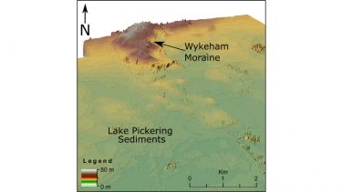
Work on the last icesheet to cover Britain has been able to reconstruct ice thickness and show that different parts of it advanced and retreated at different times. Ice in the North sea reached its maximum limits very late within the glacial stage and was dynamic, ponding up significant pro-glacial Lakes Humber and Pickering (Bateman et al 2018). More recent work has been trying to date the previous icesheet to cover Britain around 160,000 years ago (Fairburn and Bateman 2021). Over 40 publications have come from this work so far with past funding from NERC, QRA, BSG and Royal Society.
A series of time slices showing the advance, dynamics and retreat of the Vale of York and North sea icelobes of the last British and Irish Icesheet and the resulting proglacials lakes of Lake Humber and Lake Pickering (Eddey et al 2022).
Key outcomes
- Erosion of dune systems in the McKenzie Delta have been dated and tied to Lake Aggassiz outburst floods which may have caused the Younger Dryas event
- The Northsea icelobe of the last British and Irish Icesheet was dynamic and advanced to its maximum only 24000 years ago
- Evidence exists for the previous icesheet which covered Britain 160000 years ago.
Recent papers
-
Clark, C.D., Ely, J.C., Hindmarsh, R.C.A, Bradley, S., Igneczi, A., Fabel, D., Ó Cofaigh, C., Chiverrell, R.C., Scourse, J., Benetti, S., Bradwell, T., Evans, D.J.A., Roberts, D.H., Burke, M., Callard, L., Medialdea, A., Saher, M., Small, D., Smedley, R., Gasson, E., Gregoire, L., Gandy, N. , Ballantyne, C., Bateman, M.D., Bigg, G.R., Doole, J., Dove, D., Duller, G., Livingstone, S.L., McCarron, S., Moreton, S., Pollard, D., Sejrup, H-P., Van Landeghem, K., Wilson, P. and Praeg, D. (2022). Growth and retreat of the last British-Irish Ice Sheet, 31,000 to 15,000 years ago: the BRITICE-CHRONO reconstruction. Boreas 51, 699-758 DOI:10.1111/bor.12594.
-
Eddey, L., Bateman, M.D., Livingstone, S.J., Lee, J,R. (2022). New evidence for Glacial Lake Pickering, Yorkshire, UK. Journal of Quaternary Science 37 1407-1421. Doi: 10.1002/jqs.3413
- Evans, D.J.A., Robert, D.H., Bateman, M.D., Clark, C.D., Medialdea, A., Callard, L., Grimoldi, E., Chiverrell, R.C., Ely, J.C., Dove, D., Ó Cofaigh, C., Saher, M., Bradwell, T., Moreton, S.G., Fabel, D., Bradley, D. (2021). Retreat dynamics of the eastern sector of the British-Irish Ice Sheet during the last glaciation. Journal of Quaternary Science. Doi: 10.1002/jqs.3275
- Bateman, M.D., Evans, D.J.A., Roberts, D.H., Medialdea, A., Ely, E., Clark C.D. (2018). The timing and consequences of the blockage of the Humber Gap by the last British-Irish Ice Sheet. Boreas, 47, 41-61. DOI: 10.1111/bor.12256
- Fairburn, W.A. and Bateman, M.D. (2021). Possible new evidence for a Mid-Pleistocene Glaciation in the Vale Of Pickering, North Yorkshire, U.K. Proceedings of the Geological Society of Yorkshire. Doi: 10.1144/pygs2020-019.
- Understanding past aeolian activity
-
Part of my research has focussed on coastal dune systems which form a key landscape component in protecting coastal assets from coastal storms and rising sea levels. Understanding how they have developed through time and how they have been impacted by historic storms (and tsunami) will lead to a better understanding of coastal resilience as well as return intervals of impactful storms. This work has formed the basis of over 50 printed journal articles with past funding from Leverhulme Trust, National Geographic, QRA, BSG, White Rose and a NERC DTP award.
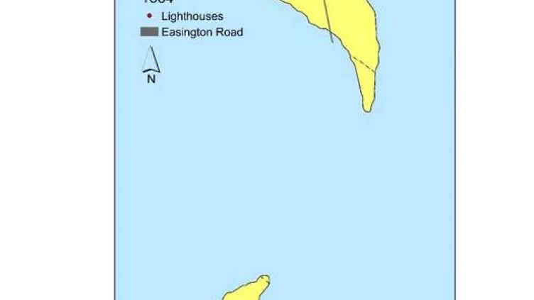
Recent work on Spurn Point has been able to show how it has evolved over the last 200 years and where it is must vulnerable to breaches by the North Sea (Bateman et al 2020).
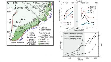
How dunes and beach ridges on the Mekong Delta has helped understand when it developed and why 19th century canalisation and agriculture might be responsible for its current erosion.
On longer time scales work has been able to show how a tsunami 8200 years ago impacted on the coastline of eastern Scotland (Bateman et al 2021) and how coastal dunes from the Atacama Desert, Chile are able to show how fast this coastline is tectonically uplifting (Nash et al. 2018).
Key outcomes
- Coastal dunes show dynamic responses to climate changes in particular sediment supply from erosion, sea level changes and storms.
Recent papers
- Carr, A.S., Hay, A.S., Bateman, M.D., Livingstone, I., Powell, D.M. (2024). How old are the Mojave topographic dunes? The implications of new luminescence dating analyses from the Cady Mountains, Mojave Desert, southwest USA. Geomorphology 463, 109349. DOI: 10.1016/j.geomorph.2024.109349
- Tamura T., Nguyen V.P., Ta T.K.O., Bateman, M.D., Gugliotta M., Anthony, E.J., Saito, Y. (2020). Long-term sediment decline causes ongoing shrinkage of the Mekong megadelta, Vietnam. Nature Scientific Reports, 10, No. 8085 . DOI: 10.1038/s41598-020-64630-z
- Bateman, M.D., Kinnaird T.C., Hill, J., Ashurst, R.A., Mohan, J., Bateman, R.B.I., Robinson, R. (2021). Detailing the impact of the Storegga tsunami at Montrose, Scotland. Boreas.
- Bateman, M.D., McHale, K., Bayntun, H.J., Williams N. (2020). Understanding Historical Coastal Spit Evolution: a Case Study from Spurn, East Yorkshire, UK. Earth Surface Landforms and Processes 45, 3670-3686. DOI: 10.1002/esp.4991
- Bateman, M.D., Rushby, G., Stein, S., Ashurst, R.A., Stevenson, D., Jones, J.M. and Gehrels, W.R. (2018). Can sand dunes be used to study historic storm events? Earth surface Processes and Landforms 43, 779-790. DOI: 10.1002/esp.4255
- Advances in luminescence dating and applications
-
The time dimension is fundamental to understanding past change. Although vast advances in dating have been made, methods all require laboratory-based protocols that are not available during field sampling. It is now possible to make in field measurements of luminescence intensity which give a first order approximation for sediment age.
Research I have undertaken (funded by NATURAL ENGLAND, WHITE ROSE and RGS) has shown how portable luminescence can be used to understand phases of coastal dune building.
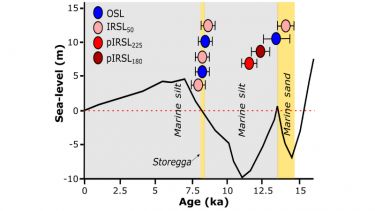
Following on from work to understand post-depositional processes on the sediment archive (Bateman et al . 2007), recently I developed an approach to used harder to reset luminescence signals (pIRSL180 and pIRSL225) to find the location of where sediment were eroded from. This was applied to Storegga tsunami deposits in Scotland which helped find the sediment source and therefore the direction of the wave that impacted the coastline (Bateman et al 2021).
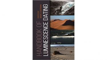
In 2019 I edited together “The Handbook of Luminescence dating” in order to demystify the technique of luminescence dating for Quaternary geologists and archaeologists who require luminescence ages for their research.
Key Outcomes
It is possible to rapidly generate accurate, high resolution down core OSL data using a portable OSL reader to enable differentiation of older from the younger sediments, identify phases of sedimentation and temporal hiatuses. Luminescence can provide information on both post-depositional disturbance and be used to locate sediment sources.Recent papers
-
Rex, C.L., Bateman, M.D., Buckland, P.C., Panagiotakopulu, E., Livingstone S.J., Hardiman, M., Eddey, L. (2023). A revision of the British Chronostratigraphy within the Last Glacial-Interglacial Cycle based on new evidence from Arclid, Cheshire UK. Quaternary Science Reviews 299, 107882. DOI:10.1016/j.quascirev.2022.107882
-
Stone, A., Bateman, M.D., Sanderson, D., Burrough, S.L.,Cutts, R., Cresswell, A. (2024). Probing sediment burial age, provenance and geomorphic processes in dryland dunes and lake shorelines using portable luminescence data. Quaternary Geochronology 82,101542. DOI: 10.1016/j.quageo.2024.101542
- Bateman, M.D., Rushby, G., Stein, S., Ashurst, R.A., Stevenson, D., Jones, J.M. and Gehrels, W.R. (2018). Can sand dunes be used to study historic storm events? Earth surface Processes and Landforms 43, 779-790. DOI: 10.1002/esp.4255
- Bateman, M.D., Kinnaird T.C., Hill, J., Ashurst, R.A., Mohan, J., Bateman, R.B.I., Robinson, R. (2021). Detailing the impact of the Storegga tsunami at Montrose, Scotland. Boreas.
- Bateman, M.D. (2019). Handbook of luminescence dating. Whittles Publishing, p416.
-
- Past Environmental Change and our predecessors
-
As our climates and environments have changed in the past so this has affected where ancient people lived and what resources they had available to them. My work has shown humans were living in coastal dune fields on the South African coast for over 100,000 years. These dunes provided a range of ecosystems and animals to hunt based on preserved animal trackways (Helm et al 2023). Thery also, through lithification, are instrumental in some (cave) shelter formation occupied by humans and dunes have been key in preserving some of the cave archaeological records found there. In West Africa research I have contributed to has shown our early ancestors were also living in tropical rainforests as long ago as 150,000 years (Ben Arous et al 2025). We have also shown that the Middle Stone extended from this time into the Holocene in places despite more modern lithic technologies being prevalent elsewhere by then (Scerri et al 2021). My work using single grain luminescence has also helped understand the impacts through time of bioturbation on sandy sediments and the archaeological sites found within them.
Key outcomes
We have a better understanding of archaeological site integrity in sandy sediments Our predecessor lived in Tropical Rain Forests and coastal dune systems as far back as 150,000 years ago.Recent papers
- Ben Arous E., Blinkhorn J. A., Elliott, S., Kiahtipes, C., N’zi, C.D., Bateman M.D., Duval M., Roberts, P., Palalano, R., Blackwood, A., Niang K.,Kouamé, E.A., Lbato, E., Hallett, E., Cerasoni, J.N., Scott, E., Ilgner, J., Escaraza, M.J.A., Guedé, F.Y., Scerri E.M.L. (2025). Humans in Africa’s wet tropical forests 150 thousand years ago. Nature (in press)
- Helm, C.W., Bateman, M.D., Carr, A.S., Cawthra, H.C., De Vynck, J.C., Dixon, M.G. Locklye, M.G., Steer, W., Venter, J.A. (2023). Pleistocene fossil snake traces on South Africa’s Cape south coast. Ichnos 30, 98-114. Doi: 10.1080/10420940.2023.2250062
- Niang, K., Blinkhorn, J., Bateman, M.D., Kiahtipes, C.A. (2023). Longstanding behavioural stability in West Africa extends to the Middle Pleistocene at Bargny, coastal Senegal. Nature Ecology & Evolution 7, 1141-1151. Doi: 10.1038/s41559-023-02046-4
- Scerri, E.M.L., Niang, K., Candy, I., Blinkhorn, J., Mills, W., Cerasoni, J.N., Bateman, M.D., Crowther, A., Groucutt, H.S. (2021) Continuity of the Middle Stone Age into the Holocene. Nature Scientific Reports 11, 70. Doi: 10.1038/s41598-020-79418-4


